Distance covered: 16.41 miles
Max height: 186m Min height: 30m
Total ascent: 707m Total descent: 628m
Well, this leg finally got walked. Initially planned for September 2nd, it was originally going to Canterbury, got diverted to Folkestone and was then postponed due to bereavement in Val’s family. Even the rescheduled leg had a bit of last minute re-organisation, when we had to accommodate three new walkers into our arrangements. The weather forecast was good for the south-east, with the likelihood of heavy wind and rain coming from the west later in the evening, so we were hoping it wouldn’t arrive early.

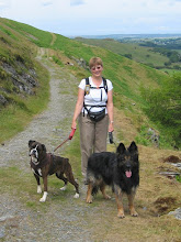
Ready for the off, Boughton Lees
The morning of the walk was also not without its problems. Simon (and friend, Denis) missed their train connection, and the meeting point proved a tad tricky to find. The directions that Anne had kindly found on the internet for Pene Quarry took you to a very small lay-by (big enough for just one car) in a VERY narrow lane. Fortunately, I was aware of a view point and parking area a mile further east and after an ‘exciting’ drive up aforementioned lane trying to find somewhere to turn round, I eventually returned to the view point and found Dave, Chris and Val already there. Our other newbies, Adeola & Daniel had to be guided to us via mobile phone directions, and therefore arrived somewhat after out 9.30am meeting time. By the time we had driven back to Boughton Lees, the others had already arrived, so it was a group of 10 (our largest to date) that set out somewhat later than planned at 10.30am.

Giraffe on the loose!
Leaving the Flying Horse Inn, we immediately came upon a quirky piece of topiary in the shape of a giraffe’s head and neck; so of course, we had to pause for a group photo.

A quick slurp while we decide which route of the NDW to take
After just half a mile, we came to the split point of the NDW, with a choice of going north-east to Canterbury or south-east to Folkestone. As we were now going to the latter we continued up the road a little further before walking through agricultural land and passed a nursery to the village of Wye. There was a mixture of orchards, ‘pick your own’ beds, and several large polytunnels - we even came across a couple of pot-bellied pigs. Some of it was a little scruffy, and the walking was flat, but there were odd glimpses of the scenic delights to come.

Perry Court Farm

A hint of scenic delights to come......
Before reaching Wye high street itself, we had to negotiate the railway line where the level crossing and subsequent road bridge over the River Great Stour were partly blocked with workmen and their vehicles. I bet they were on double time! The river was very pretty in the sunshine, with huge old weeping willows overhanging the water.

River Great Stour, Wye

Church Street, Wye
The high street was picturesque as well, and there was a café on one corner doing good trade on such a lovely autumn day. Once Anne spotted that they sold ice-creams there was the inevitable delay while she indulged her ‘addiction’. While we were waiting, some of us sauntered up the road towards the church, where Dave & Chris popped into a newsagent to buy chocolate. Our route took us through the churchyard and briefly up a road passed horticultural buildings - probably something to do with Wye agricultural college which is now part of Imperial College, London.

Wye Church

Climbing Wye Downs
Finally we began to climb the Wye Downs up a fairly gentle incline - the views back over Wye and to the south were starting to impress. Before entering a wood and continuing to climb a little more steeply, we passed an unusual wooden seat, which of course presented another photo opportunity.

Zuka poses on wooden seat, and Daniel just poses!

Lovely view north from top of Downs
Leaving the woods, we reached a lane with fine views north to a deep valley. Finally reaching the top of the ascent, we emerged back onto the Downs above the Crown Memorial (celebrating the coronation of Edward VII in 1902), cut into the hillside. The memorial itself was difficult to view from directly above, but had apparently been restored between 1990 & 1995 by students of Wye College. There were also some more recent additions to the site in the form of a curved stone seat and central stone structure.

Stone seat at Wye Crown

View over Wye
An unofficial stone NDW way marker commemorated the life of a Warrick Rance ‘who loved walking these Downs’, and also confirmed we had completed an impressive 101 miles of our journey. Here Zuka met a couple of lurchers and was, I have to say, severely out-run!

Wye Crown

Our path along the top of the Downs
Walking along the ridge of the downs in the autumn sunshine, with a cool breeze blowing, was really delightful. The guide book suggested you could just see the sea from here, but we weren’t quite sure. After about half a mile, some woodland obstructed our view briefly, but then it was back into the open downland again in the Wye National Nature Reserve on Broad Down. Here we came to the deep bowl-shaped dry valley called the Devil’s Kneading Trough, which is believed to have been formed by melt water over a period of about 500 years, some 10,000 years ago.

Devil's Kneading Trough
After passing the buildings of Cold Blow farm, we stopped for lunch in a field, some of us using the straw bales as wind breaks or back supports. By this point it was clear that we had been making fairly slow progress, covering less than 6 miles in 2.5 hours, so our stop was a little shorter than usual, and we determined to up the pace a bit.

Descending the lane on Braborne Downs
For the next few miles our route followed green lanes, farm tracks and tarmac lanes, and the views were pretty good throughout, particularly on the lane near Partridge Wood. We finally descended from the downs on a path lined with hawthorns.

Hawthorne tunnel
Approaching the village of Stowting, the path ran through the fields parallel to the lane, which meant climbing a large number of stiles (the guide book suggested seven, but I’m sure I heard someone say it was ten). We could have stayed on the lane and avoided all this exertion, but then we would not have been keeping to the official path, plus we would have missed the opportunity of lots of silly stile-climbing photos. We had our work cut out getting Zuka over some of them too, as most of them weren’t very dog-friendly.

Me entering the "field of many stiles" - Stowting

"Does my bum look big in this?"
Passing the busy Tiger Inn, I was tempted by the lingering smells of Sunday lunch, whilst Daniel could barely conceal his disappointment that we weren’t going to let him stop and have a pint. This was obviously a horsy area, and the pub sported a car park AND a horse-rail. The other unusual sign we met here was a road warning sign for moose! Surely this was a joke? New boys, Daniel and Dennis did a pretty good impersonation of the beast for the benefit of Anne’s camera.

Oneupmanship at the Tiger Inn, Stowting

Spot the difference!
Leaving the village, Zuka had the opportunity to cool off in a stream running beside the road. Turning off the lane, we climbed steeply on a narrow wooded path up Cobbs Hill. The trailing group had to wait for a posse of motorcycles to pass them before they could join us.

Climbing Cobb's Hill

View from Cobb's Hill
Emerging into the open once more, we continued to climb more gently on open downland with the views south and west continuing to impress. Reaching the top at Farthing Common, the path ran parallel to the road for a while, first across agricultural land and then pasture, where there were both cows and sheep grazing (and their inevitable deposits to avoid). Crossing a side road, it was a little disconcerting to see a sign for the Tiger Inn which we had passed some time earlier.

Crossing the lane back to Stowting

Simon reverts to childhood at Farthing Common
After dicing with death, avoiding fast moving traffic on the Etchinghill road, Simon had the chance to revert to childhood on a simple tree swing. Well, it had to be done…….. The way was not obvious as it meandered through the trees, and we decided to ignore a curiously placed waymark arrow that appeared to direct us through a large bush. Emerging from the wood into fields again, the English Channel was now clearly visible, and we took the opportunity to have a quick break here.

"Say cheese"

First view of the English Channel
Shortly after moving off, Daniel had to stop again to attend to his sore feet as he had developed an enormous blister – I thought he had become a bit quiet… Fortunately, Sally came to the rescue with a Compeed plaster, although opening the packet proved a tad difficult. Continuing, our way took us on delightful grassy paths through rolling downland. There were curious ripples in the earth, making the hills look as if they were wearing contour lines. I think we diverted from the official route here slightly, as the map indicates we should have descended further than we did.

'Contour lines' on the hills
As the path continued to meander round the hillocks, we had lovely views of the sea, which was getting a lot closer now, and over the pretty hamlet of Postling (where apparently Joseph Conrad wrote some of his greatest novels, although I have to admit I’ve ever heard of him).

View over Postling

Steam Engine, near Etchinghill
Dropping down to the road, we could hear and smell what we initially thought was a steam train, so we hurried to the junction to take a photo – it turned out to be some kind of traction engine chugging along the road. We walked along the quiet lane to the next junction and came across an old car being sold in the lay-by – not sure I would have touched it with a barge pole for £586 (but purchasing Chris for £587 may have been a bargain).

What a bargain!

On top of the Downs again
Leaving the road, we climbed towards a large radio mast, set on one of the highest points on the Downs (a rather paltry 181m). It is jointly owned by the Civil Aviation Authority and MOD. Our path (which was also a bridleway) continued through the military training area. A sign helpfully warned us that there may be blank ammunition fired at any time of the day or night – not sure I’d want to risk riding there!

Tolsford air traffic radio mast

First view of Chunnel terminal
Before descending once more to cross a road, we had our first view of the Channel Tunnel marshalling yards, and felt we were now on the home run. Passing under a Victorian railway bridge, we emerged into a grassy valley, and it was abundantly clear that the only way forward was also UP. It was a bit of a slog, and just when you thought you were nearly at the top, there was a sting in the tail, as the path turned to the right and became even steeper. Phew! Daniel was flagging a bit (more to do with the pain in his feet, I think), but Adeola managed a smile for the camera.

A bit of a pull - Phew!

Another hawthorn tunnel
For the last couple of miles the path essentially followed the cliff top path, with fine early evening views over the Chunnel terminal (curiously attractive in a futuristic kind of way), Folkestone, the English Channel and finally, on the horizon, France. Although feeling a little weary now, I wasn’t sure I really wanted this super walk to come to an end. We passed another stone waymarker – 115 miles completed, and Dave got down on his knees to pray (no, sorry…….. he was just taking a photo, my mistake!), and soon afterwards passed through Pene Quarry, our original finish point.

Two thirds of the way completed

Winter wheat
However, we continued for another mile or so, seeing a rather acute view of the Folkestone Millennium White Horse on the hillside immediately below our cars (designed by Charles Newington, the best view of this is apparently to be had from the Tesco car park in Folkestone), skirting the edge (or occasionally cutting the corners) of fields sown with winter wheat, before arriving tired, but triumphant at the lay-by.

Simon & Dennis above Chunnel Terminal, Folkestone

A very tired Daniel
Well, I thought this was the nicest walk we had done to date. It was a long one at nearly 17 miles (Adeola couldn’t believe she had walked that far – Daniel could, his feet felt like he’d done 117), but the weather had been almost perfect (in fact, had got better and better as the afternoon wore on) and most of the paths and views had been fantastic. Finally, the company was even more sparkling than usual – brilliant!


0 comments:
Post a Comment