Distance covered: 16.86 miles
Max height: 206 m Min height: 2m
Total ascent: 950m Total descent: 904m
This account covers the ‘alternative’ walk taken by Dave & I, since neither of us could make the official one scheduled for 5th August. I woke to thunder storms and heavy rain and wondered if it might be better to postpone the walk until the following weekend, but by the time we met at Hollingbourne, the worst of the weather had moved away north, and it was dry, if rather overcast. It was also noticeably humid, a weather feature that was to plague us during a very long day. As most of the pictures here were taken by Anne on the 'official' leg they show much more blue sky than we encountered. 

We started our walk at the Ranscombe Farm Reserve car park near Cuxton, and almost immediately crossed the River Medway on the same bridge that was carrying the M2. Nearing the other side, where the bridge overlooked the houses of Borstal (isn’t there a ‘holiday home’ for a certain type of teenager there?), there were some Perspex screens between us and the traffic, placed to reduce noise pollution to the town, and they certainly appeared to do their job quite effectively. Looking back the way we had come, there were views of Rochester castle and the cathedral spire. After dropping down and passing under the motorway, we soon (fortunately) turned south and away from the drone of traffic, and began the inevitable climb to the crest of the Downs.


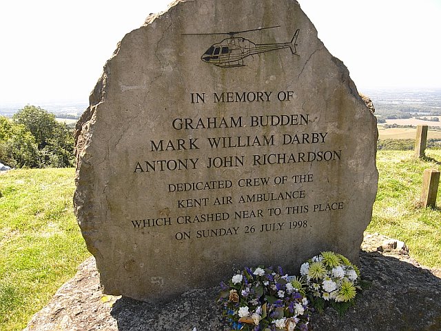
Our path was initially alongside arable fields, with good views back towards the bridges, but soon became a stony byway with much of the views obscured by trees. We passed a sign for the isolated Robin Hood pub and continued along the byway to reach Blue Bell Hill picnic site and view point, where we stopped for a breather and some liquid refreshment. Standing proud in the car park was a memorial to the Sussex Air Ambulance that crashed locally in 1998, killing all three men on board.

Our route followed the A229 for ½ mile, but thankfully the path was separated from it by trees. We soon reached Kits Coty House – three huge stones plus cap stone – part of a Neolithic Long Barrow burial chamber. To prevent further damage, the site is now guarded by iron railings, but allegedly, some of the graffiti is over 130 years old. Continuing on a pleasant sunken path, we arrived at an unusually shaped underpass beneath the A229. Fortunately, despite the earlier thunderstorms, the passage was dry – last time Dave had been this way the tunnel had been flooded to well over boot level. Energy levels were running a bit low at this point, so we popped into the petrol station to buy chocolate - the air conditioning in the shop was rather nice too.


Leaving the garage forecourt there was an unusual carved metal marker post, which was actually for a national cycle route, but was still interesting enough to photograph. Following the slightly ambiguous way marks, rather than looking at the map or GPS, I then set off in the wrong direction, but as Dave had been here before, he quickly realised my error, and we retraced our steps (confronting a youth with a motor cycle who definitely looked up to no good). We crossed the Channel Tunnel rail link for the third time that day and then, walking along an attractive sunken path, passed another Neolithic monument called White Horse Stone, which was not nearly as impressive as Kits Coty, and not white either, come to think of it.

Sharing our route with the Maidstone Centenary Walk, we now climbed very steeply, gaining over 100m in half a mile. The guide book described the climb as ‘reminiscent of Box Hill’ and we wouldn’t disagree! As the path flattened out we passed another mile stone (79 miles completed) and my prayer was briefly answered when the sun popped out to brighten up the woods, and cast some dappled shade. At the edge of the wood small standing stones had been used to construct a stile.

The path now skirted a large arable field, and light rain had started to fall. However, after the long climb, plus the warm air temperature, neither of us bothered to put on our coats, and the rain did not continue for very long. The wooded scarp slope was to our right but there were no views, except where the trees had been cut back to allow the passage of electricity cables strung between pylons.

We had a late lunch in Boxley wood, then continued on the bridleway through scrubby woodland for just over a mile. As intermittent sounds from the nearby Kent Show reached us, the route then followed a narrow sunken lane to the bottom of the scarp and turned left towards Detling. We crossed the busy A249 on Jade’s Bridge - erected after the death of Jade Hobbs and her grandmother while crossing the dual-carriageway in December 2000. After crossing, I dropped some loose change in the collecting box. As we left the village on the Pilgrims Way, we passed an impressive Tudor gateway set into the stone wall.


Our path soon climbed the Downs again and we walked along the rolling chalk hillside alongside the White Horse Community Wood. The views south and south-east were now starting to become very good, albeit rather hazy. In a cruel twist, the route then crossed a dry valley which involved descending some very steep steps with a slightly gentler climb up the other side. Reaching a narrow road, we decided to forgo a visit to Thurnham Castle (up more steps) as the guide book suggested there was not much of it left anyway.


After walking along a scrubby chalk path for about ¼ mile, we reached an arable field and were then a little unclear of the route, as there did not seem to be an obvious path in the direction of the marker arrows. We therefore took a clearer path into a grassy field, which did initially appear to be in the correct direction according to both map and GPS. Another ¼ mile on, and I was now convinced we were not on the right path after all, but we continued to the field boundary and walked steeply back uphill along the fence line (to the bemused looks of some young beef cattle), hoping to be able to get back onto the NDW at the top. Unfortunately, there were thick brambles and scrub between us and where we believed the correct route to be. We back-tracked along the fence, until we found a gap in the scrub and ‘hey-presto’ there was the path, but unfortunately on the other side of the fence (stock wire plus two strands of barbed wire on top). We did manage to struggle over – although far from elegantly, at least on my part!

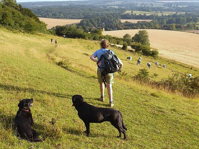
The route now switch-backed through woodland and scrub for about 1½ miles, with several more sets of wooden steps to negotiate. Finally emerging from the wood over a stile that had a very long drop on the far side (I’m glad we didn’t have to climb it from the other direction), a splendid panoramic view awaited us – lovely rolling countryside and undulating arable fields. We decided to savour the moment and rested on the hillside in the shade for ten minutes. While enjoying a cup of tea, we spotted two other ‘proper’ hikers – unbelievably the only other booted and ‘ruck-sacked’ walkers we saw all day – but they were not walking the NDW, so our paths did not cross.

With several more miles still to walk, we hauled ourselves back to our feet for the final assault. The path initially swung north round a spur then settled in a roughly south-easterly direction, where apart from a couple of small wooded sections, it continued mainly across open downland. Finally, we began our descent to Hollingbourne, which had been tantalisingly visible for the last mile or so. Unfortunately, Dave suddenly realised he had lost his camera somewhere over the preceding few miles, but we decided to continue down to the car initially, to finish our longest section to date, at just under 17 miles.

After a quick drink at the uninspiring ‘Dirty Habit’ pub, we drove the car back to where our route had crossed a narrow lane a couple of miles from the finish – and that was an adventure in itself! Then, I walked one way and Dave walked the other. Thanks to mobile phone technology, and the fact that we actually both had signal coverage (amazingly unusual in an ‘emergency’), Dave was able to ring me after about 15 minutes with the good news that he had found the missing camera. We returned to the car with a further mile or so under our belts. This would certainly be a section that neither of us would forget.
***************************************************
Brief notes re ‘official’ Leg 6 – Sunday 5th August
There was some confusion regarding the meeting point, with cars waiting at three different pubs in the Hollingbourne area. Eventually the group all found their way to the Dirty Habit, and returned to the Medway Bridges in one car, although it did mean a later than usual start. As Dave & I were missing, and both Simon C & Martin had not joined us for some time, there were just five walking today (Anne, Simon S, Sally, Val & Chris). Zuka had a friend though, as Anne was looking after her friend’s Labrador, Maggie.


The forecast was for a hot, sunny day, and it was certainly pretty warm (and noisy) as they made their way over the Medway bridge alongside the motorway. However, a breeze picked up as they headed up the Downs, which helped.


Wonderful display of hydrangas along Hill Road
Anne had bought herself a new camera and was taking even more pictures than normal. Consequently, at the A229 underpass, she had got a bit left behind, and could not believe her eyes when she saw the rest of the group returning towards her pushing an abandoned ice-cream freezer (sadly empty)!


When they reached the Shell garage the group unfortunately made the same mistake as Dave & I, and turned left by the National Cycle Route marker. There was a van partially blocking the correct route across the railway bridge which made it difficult to see. Val’s guidebook also turned out to be rather older than she’d thought, as it was written before the rail link was built, and was therefore inaccurate at this point. With hindsight, it was a shame I didn’t tell them about my navigational error here a few weeks earlier. As Dave knew the area, we had only gone off track for a short distance, but the main group continued to Lower Warren Road before turning round, which meant that, once back on route, they had added a full mile to the walk.

Having just passed the pylons in the large arable field at the top of that very steep ascent, they nearly missed the waymark directing them into Westfield wood on the edge of the escarpment. Unfortunately, the group then did miss the marker post directing them left and back out of the wood almost immediately, which meant a brief ‘lost in the woods’ moment, before they were back on track.


Eventually they reached Detling – which Chris said seemed to take forever - the navigational errors wouldn’t have helped. Luckily, they didn’t make the same mistake as Dave & I near Thurnham, although there was some route discussion at this point, and the map was consulted. Anne’s map-reading skills were obviously up to the mark and they took the correct route.


By the time they reached the lovely viewpoint at Cat’s Mount they must have all been feeling pretty hot & tired, and Sally admits she was dreaming of the finish when she was photographed looking at the map. Val was also getting a bit tetchy, apparently. Anne’s focus of irritation was more canine than human, as Maggie had continually refused to drink from any of the offered containers, and in view of the temperature, she was understandably worried that the dog was getting dehydrated.
They finally reached Hollingbourne in the early evening, to a welcome drink at the Dirty Habit. Like me, Chris was not altogether impressed with the place, but at the end of long, hot day, who cared?


0 comments:
Post a Comment