Distance covered: 13.5miles
Max height: 269m Min height: 59m
Total ascent: 464 m Total descent: 626m
Today’s weather forecast was not promising, and the waterproofs were to feature again on this section, if only occasionally. Martin and both Simons were absent at roll call, so it was a depleted group of six that set off from Titsey Place car park. The early walking though thick woods was pretty gloomy, as it was so overcast, but at least the path led gently downhill, so it was an easy start to the day - although one had to be careful of wet tree roots, which were VERY slippery. 

Eventually we emerged into arable fields and climbed again, passing an unusual wooden sculpture alongside the B2024. The way continued up Chestnut Avenue, where, in addition to an attractive NDW map, there was also a council sign suggesting that the area was used for ‘various unlawful purposes’! This caused certain imaginations to go into overdrive, and lowered the tone of the conversation for much of today’s walk. The road passed the golf club and some rather posh houses (with guard dogs on duty) before degrading to a gravelled track as we descended once more. Twisting and turning through woods, we crossed the Surrey/Kent border, and passed a milestone celebrating the completion of our first 48 miles of the NDW.

After crossing the Biggin Hill/Westerham road, we climbed through fields again, gently at first, but then more steeply. The light rain was only intermittent at this stage, but the views were unfortunately rather diffused by low cloud. Our route continued in similar vein for some time, crossing or running parallel to minor roads. Along its length, the route of the NDW is indicated by various types of way marks (arrows, acorn marks, wooden finger posts, engraved stones etc), but now we had reached Kent we also came across smart new metal signs on wooden posts. These were principally used at road junctions, and the other variations continued to be seen elsewhere.

Crossing a field of young cattle, we turned south round the corner of a wood to be met with what looked like a grey sea – there was no view at all. This was a bit of rather nasty weather that soon enveloped us and required hasty donning of waterproofs. The rain, although quite heavy, only lasted 10 minutes or so after which things slowly improved again.

A couple of miles further on we stopped for lunch at the edge of a field near Knockholt. There was a chilly breeze blowing here so we did not linger long once the sandwiches were consumed. Refreshed, we continued on, twisting and turning along the scarp top for a couple of miles before descending to the Sevenoaks road and crossing our ‘friend’, the M25, on a road bridge. The trail followed the A224 for a while, where we passed an attractive thatched cottage with lovely distant views, but its location was somewhat spoiled by being right on the busy main road. At Donnington Manor Hotel, we were glad to turn off the road onto a footpath once more, initially sharing our route with the Darent Valley Path.

Our way continued through arable fields and offered pleasant views of rolling countryside. Even the weather had improved - there was much more blue sky, and even the odd ray of sunshine. The drinkers amongst us got excited by a printed sign for the ‘Great Kent Pub Walk’, but we did not see any of the participants until we reached Otford. Before reaching the town, however, we passed a lavender farm, with many acres of lovely mauve flowers in characteristic elongated mounds. Anne picked a few heads (on the basis that it was a crop and not wild flowers!), and us girls carried them for the rest of the walk, enjoying their scent.

Otford high street was smart with nice houses and many art galleries and antique shops. The pond, with its resident ducks and beautiful willow trees, was also charming, BUT, this long stretch of road walking was not to most of our tastes. Finally leaving the town behind, we were now only a couple of miles from the finish of our walk, but unfortunately had to climb Otford Mount first. After catching our breaths, we continued though a grassy meadow with fine views across the Darent valley, before reaching a minor road junction where there was lay-by with parking space for several cars – which got us thinking about the start point for our next walk…….

After passing the end of the driveway to Otford Manor, we continued on a narrow woodland path, and into a nature reserve run by the Kent Trust for Nature Conservation. By the time we reached the first footpath down to Kemsing, we had decided to start our next walk from the aforementioned lay-by. This would involve covering a fairly flat ¾ mile section of the NDW again, but would avoid having a steep, un-necessary climb up to the trail at the beginning of a long day’s walking (no contest). 

As we began our steep descent off the trail, the views were wonderful, especially as the sun was again making an appearance. Finally, we followed the road back to the public car park by the Wheatsheaf pub, where we had left our vehicles. Before dispersing, we had a quick ‘bevvy’ and Anne sent malicious text messages to the absentees. The weather had certainly not been as bad as forecasted, and some of the walk was very pleasant indeed, but I think most people agreed this was probably one of the less interesting sections we had completed so far. It was also one of the quietest – apart from the towns & villages, we only passed two walkers all day.
Sunday, 25 November 2007
Leg 4 Titsey Hill to Kemsing (Sunday 1st July 2007)
Looking SW to Pilgrims Farm
Wooden sculpture by B269
Nearly 1/3 of the way completed
Val enjoying the views
Kent CC signs
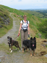
Happy walkers
Enveloped by a nasty bit of weather.........
..........but still smiling!
Thatched cottage on A224
Exposed chalk on the Downs
Lavender fields approaching Otford
Story of Otford village to mark the Millennium
Looking a bit weary now!
Glorious view
View south over Kemsing
Descending towards Kemsing
![]()
Subscribe to:
Post Comments (Atom)


0 comments:
Post a Comment