Distance covered: 15.5miles
Max height: 231m Min height: 15m
Total ascent: 690 m Total descent: 857m
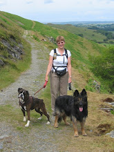
As previously agreed, we started today’s walk with a short re-cap of NDW Leg 4, beginning at the top of the hill just west of Otford and re-walking a ¾ mile section of the trail. We had three absentees again (with some variation), so were a modest group of six once more. Simon S made an equine friend in the first field, who was quite keen to join us, but as it wouldn’t have fitted through the kissing gate at the field boundary, had to resume its grazing and let us continue ‘sans equus’. Horses in subsequent meadows were content just to watch our progress with only minor interest. 

Leaving a minor road at Highfields Farm, we were a little unclear of our route for a few minutes, which resulted in a climb over a high, rickety fence to get back on track, where Anne picked up a splinter in her hand. In the meadow beyond, while waiting for the stragglers to catch up, Simon S made good use of a couple of minutes rest time and lay spread-eagled on the grass – takes a while to ‘warm up’ into a walk, does Simon!

Our path continued roughly eastwards though arable fields and woods, and there were some wonderful views to the south – the visibility today was by far the best it had been on any of our walks to date, making the countryside look all the more beautiful in the sunshine.

Crossing another road, we walked down some steps through the woods before descending more gently through an arable field, where Anne got delayed photographing poppies growing as ‘weeds’ amongst the corn. At the bottom of this field was a curious large dark patch, which from the top of the hill reminded us of a crop circle. However, on closer inspection (and Simon S inspected it VERY closely by putting his foot in it), it appeared to be some kind of manure dump.

Swinging east once more, we followed a farm track for a couple of miles. The track was hemmed in for much of the way between hedges, but there were occasional lovely views both south, over rolling farmland, and north to the downs themselves. It was here that Zuka made her second catch of our NDW adventures, although we believe this one was already ‘deceased’ before she found it! Very pleased with herself, she appeared with a partridge/pheasant (?) in her mouth, and again took some persuading to give up her trophy. Even the lure of Anne’s sandwich was not sufficient incentive (unusual for a Labrador). Once dog and prize were finally separated, we had to keep a sharp eye on her for a while to stop her doubling back to retrieve it again – well she is a gundog.

Finally we arrived at the houses on the outskirts of Wrotham, and followed first a minor road, and then briefly, the A20, as we crossed the M20 on a road bridge. Our route now swung north-east with the Downs themselves, as once again we followed the route of the Pilgrims Way on a quiet lane. The path meandered between the road and fields along this attractive section, and we took advantage of a shady spot under a tree in the field just past Hogmore Farm for our lunch. There was quite a cool breeze blowing, so the heat-worshippers amongst us preferred to sit in the sun.

After lunch we continued briefly along Pilgrims Way before climbing back up through woods onto the chalk Downs once more. Crossing the A228, we began to walk down the road to Trottiscliffe before branching off into Trosley Country Park just before an elegant flint bridge. The beauty of the surroundings was a little marred by a powerful odour of drains, but fortunately this had dispersed by the time we reached the visitor centre, where we used the facilities to the full – both loos and refreshments.

Our route continued on a level, wooded path through the Country Park for a little over a mile. Strangely, many of the plastic way-marking arrows for the NDW had been removed from the wooden posts, but the way was easy to follow so there was no problem. We were following part of a ‘trim trail’ through the park, and both Simon S and Chris showed how manly they were by attempting several pieces of the apparatus.

After a brief climb, we turned right (where the way-marking now went into overkill, with an arrow, a National Trail acorn, and an engraved stone) down a steep track and off the ridge once more. At this point we considered a brief diversion to see the Coldrum Stones long-barrow, but we were not sure exactly how far off trail it was, and the path to it was downhill, in the wrong direction, so only Anne ventured off to explore. She soon returned disappointed, however, as the stones were obviously a bit more than the ‘short stroll’ mentioned in Valerie’s guide book.

Merged with the Pilgrim’s Way again, our path followed the downs as they began to turn north-east. The walking was easy, the weather was perfect and the views were gorgeous, even though we could see a bit of industrialisation in the form of a paper mill in the distance. It was not totally peaceful, but you could only hear a distant hum from the motorway some way off to our right, and fortunately it was pretty much hidden from view by trees. The downs rose up to our left. Strangely, on this relatively open section, the GPS had great problems getting a signal, so I can only assume the satellites were all having a get-together on the other side of the downs.


Unusually, for the next mile or so our route went northwards and we soon passed Holly Hill house, which being right on the ridge, must have had the most fantastic views to both east and west from its upper storey. Leaving the road, and entering Greatpark Wood, we were nearly mown down by 2 jeeps emerging from our route. At that point they were actually quite within their rights, as for a short distance the trail followed a BOAT (byway open to all traffic). Their legacy however, was a wet, rutted path, and Sally decided that mud-splattered legs were absolutely the thing to wear this summer. The OS map showed a large chalk pit lake close by, but this was unfortunately hidden from our view by trees.

On we trudged, getting a little weary now, though alternating woods and meadows. Once again, the ‘boys’ showed off by walking over a rather dilapidated wooden bridge. The girls sensibly stayed on the footpath and simply walked round it.


In a long northward sweep, the path took as up and down through some lovely rolling countryside and through the delightful hamlet of Upper Bush, where we had a short rest.


On the final mile or so of our walk we skirted the edge of Cuxton, crossed the railway, and looped northwards once more before finally heading back towards the A228 (with our first good views of the River Medway) to and our waiting cars.


The day wasn’t quite over yet however, as, after returning to the start point and picking up the remaining two vehicles, we had a very nice meal in the garden of The Chequers Inn, just east of Kemsing. For me this section was definitely the best so far – what a wonderful way to spend the day!


0 comments:
Post a Comment