Please note that all photos on this blog belong to members of my walking group. They request that none are reproduced without permission. Thank You.
Sunday 25 November 2007
Leg 11 Canterbury West Station to Boughton Lees (Sunday 11th November 2007)
Distance covered: 12.96 miles
Max height: 167m Min height: 11m
Total ascent: 539 m Total descent: 479m
Well, today was to be our final section of the NDW. Simon had persuaded Dennis to join us again, and we also had a brand new walker (Mike from Essex), so there were eleven in the group today – our biggest of the entire trail. With about 13 miles to walk, and the fact that the clocks had now changed and the nights were really drawing in, I was particularly keen that we made a prompt start, and fortunately we managed to get away just before 10am. The weather was very overcast, with rain threatening.

Ready for the off - Canterbury West station

Dave photographs the gates at Hindora Heights
We walked through the outskirts of Canterbury for about a mile, crossing the A290 in an underpass, and light rain had started to fall. Soon the residential streets ended, and after passing the impressive gateway to Hindora Heights, we began to descend on a sunken lane, ankle deep in rustling fallen leaves. Indeed, such paths were to be a prominent feature of today’s walk.

Ankle deep in leaves

Form an orderly queue, please....
The path gradually descended to cross the A2, which was relatively quiet this morning, passing our only horse field of the day (that I can recall, anyway). The leafy paths then continued for about half a mile before we emerged in “No Man’s Orchard”, where, being 11am on Remembrance Sunday, we stopped for a two minute silence. The rain had fortunately stopped by now.

Val & Sally toning nicely with the Autumn colours

Scrumping in No Man's Orchard
Some of the boys were feeling a bit mischievous and scrumped a few of the apples still remaining on the trees – although most had clearly been harvested. Continuing through the orchard we found an enormous ‘serpent’ carved from a fallen tree stump which was really very quirky. Having eaten an apple herself, Anne suggested she might turn into Eve and lead us all into temptation. Well, she is inclined to do that every time we find anywhere selling ice-cream anyway!

Have we stumbled on the Garden of Eden?

This way, that way, and scoop that poop!
Our first village of the day was Chartham Hatch, which was much more modern than the lovely villages on our last section. While walking down a residential street we waved to two little girls observing us from an upstairs window. Although we probably looked a pretty ramshackle bunch, they fortunately didn’t run screaming to their parents in alarm. In someone’s driveway we spotted a pretty unusual old car with eyes painted over the headlights. It appeared to be taxed, so presumably it is only taken out for a spin in daylight.

Here's looking at you..

Leaving Chartham Hatch in a welcome bit of sunshine
Passing the Chapter Arms pub, we left the village and continued down the lane flanked by more orchards, and the sun very briefly showed its face. Up until now there had been no far reaching views, but they were now finally opening up a little to the south. Leaving the road at Hoppers Oast house, Daniel and Dennis attempted to imitate the road sign depicting an HGV grounding on a hump in the road. I have to say their impersonation of the moose sign on NDW8 was a little more successful!

Er, 5/10 for effort, boys!

Acres and acres of apple orchards
The route initially took us alongside Fright Wood, with acres and acres of apple orchards stretching away to the south, and then down a sunken path to pass under the railway. With so many orchards in the area, it was not surprising to come across a mobile home ‘village’ – obviously sited to house the hundreds of migrant workers who must be needed to harvest the fruit. It was also not surprising to see that the car parked alongside one of the few caravans that still seemed to be occupied this late in the season, had a Polish number plate.

Avenue of trees close to Old Wives Lees

Village sign
Reaching a lane again we turned towards Old Wives Lees (some interesting place names in this neck of the woods), another modern village. Thoughts had begun to turn towards lunch as it was about 12.30pm and we didn’t want to eat too late, since we would be having an early supper. With a fair bit of road walking to do, the best spot we could come up with was the local green and playground. Unfortunately light rain started again at this precise moment, and most people sheltered under a tree to eat their sandwiches. Simon & Dennis found a rather more unusual spot in the tunnel of the children’s play equipment.

A damp lunch

Simon & Dennis shelter from the rain
Although the early part of the walk had not been particularly cold, the brief stop in the rain had caused quite a chill, and there was some donning of extra layers by a number of the group, myself included. Leaving Old Wives Lees, we continued down a very attractive lane alongside which sheep grazed among the apple trees in the inevitable orchards.

I wonder if sheep eat apples?

Ancient Yew stump at Chilham church
Crossing the A259, we soon reached the picturesque village of Chilham and several people had a quick look inside the 15th century flint church. They were apparently selling produce and books inside, and I believe Simon purchased some more reading material (to go with his World War II books purchased on NDW9). In the churchyard were the remains of an ancient yew that had been killed by falling trees in the great storm of 1987.

Chilham Square

Do they sell ice-cream?
Chilham square was quite charming with picture-postcard, half timbered Tudor & Jacobean buildings including a pub, and gift shop. The overall view was somewhat marred by the numerous cars parked there, but ‘hey-ho’, such is modern life. Leaving the square we passed the entrance gates to Chilham Castle (actually a 17th century manor house).

Chilham 'castle'

The oddly named Mountain Street
The route continued out of the village on a delightful lane called Mountain Street, with views to the west over Chilham Park and its equestrian cross country course. For the last mile or so I had noticed the cloud cover gradually moving away southwards, and now we were finally bathed in glorious autumn sunshine. Although it was only mid afternoon, the shadows were already lengthening, a reminder that there was only a couple of hours of daylight left.

Chilham Park in the sunshine

Felborough Wood
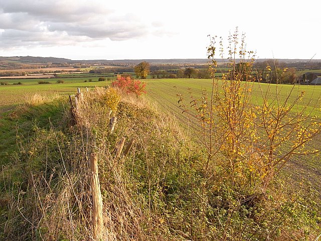
At the end of the lane the route became a leafy byway, and there was a bit of a slog up the hill to reach the top of the downs. On the way up we had to make way for two 4-wheel drive vehicles which were (unfortunately) exercising their rights to travel on this lovely path that was barely wider than them. As we reached the top of the rise, we entered a really beautiful wood. The combination of autumn colours and afternoon sunshine providing a visual and olfactory treat that was truly breathtaking – lovely!

Wonderful Autumn colours

King's Wood
The attractive path continued through King’s Wood for several miles on the edge of the scarp slope of the Downs. This part of the wood was essentially chestnut copse. Walking behind me, Chris & Mike discovered they had a shared passion for cricket and their conversation baffled me for some time.

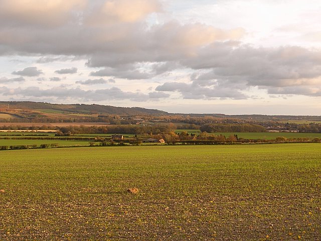
Views south west from the scarp
View south
When we finally descended off the scarp, the views towards the south were very good, and I could just make out Wye nestling at the foot of the downs a few miles away. As the photographers got a little delayed with the views, the leading group forged some way ahead, and Dennis took a short cut across the corner of a winter wheat field to catch up – naughty boy. The leaders waited at Soakham Farm where they found a convenient wall to sit and wait for the stragglers. Dennis & Simon found a more comfy spot in the hay barn.

Soakham Farm - Cheers!
Views south east towards Wye Downs
Our final couple of miles entailed squinting into the setting sun as we walked in a south westerly direction. On a short piece of enclosed path, Dave played Tarzan on a thick piece of hanging vine. We then crossed a large unploughed stubble field where there were two people with metal detectors hunting for hidden treasure. Anne found her own treasure to photograph in the form of lovely red poppies.

Wye Downs - you can just see the Crown

Boulton Aluph church
We passed through the small hamlet of Boughton Alph with its fine square towered church before finally reaching the lane leading back to Boughton Lees. As this was where the NDW divides on its way to Dover, this was actually the official finish point of our journey. Understandably, we stopped for some celebratory group photos before walking the last half mile back to our cars in the village.

Mission accomplished - NDW complete!

Sunset in Boughton Lees
As it was only 4pm, and Michael was not intending to return with the rest of us to Canterbury for a meal, we had a drink in the Flying Horse, where I presented official NDW certificates to those of us who had walked the entire trail – Anne & Zuka, Sally (the only ones who had done all eleven ‘official’ walks), Val/Chris (who had completed the entire walk between them), myself and Dave.

Sally receives her NDW certificate in the Flying Horse

Well done, Anne & Zuka

Congratulation, Dave

Good team effort from Val & Chris..

and well done to me, too
We then drove back to Canterbury West station and walked through the city centre to Azouma, a cosy Moroccan restaurant, where we had a splendid meal to celebrate the finish of this adventure.

Floodlit Canterbury Cathedral

Celebratory meal at Azouma, Canterbury
I think I can speak for everyone when I say that we all thoroughly enjoyed walking the North Downs Way. We became quite intimate with the motorway network of Southern England, experienced some really wonderful and varied scenery, and for the most part, were extremely lucky with the weather (particularly considering 2007 has been the wettest summer on record). The trail was easy to follow (we only got lost a few times), and well maintained. Although we were strangers at the start (apart from Val & Chris and later additions, Daniel & Adeola who are married), we have enjoyed getting to know each other, and are certainly planning to walk a new trail in 2008. Watch this space........
Leg 10 High & Dry pub, Waldershare to Canterbury West Station (Sunday 14th October 2007)
Distance covered: 13.98 miles
Max height: 122m Min height: 10m
Total ascent: 286m Total descent: 357m
Val unfortunately had to miss her second walk in a row, as she only arrived back from the Frankfurt book fair at some ungodly hour in the morning - we missed her (and the promised sausages). Simon, who was trying to impress a new girlfriend, had agreed to go to the opera that evening, and as the show started at 7pm was unable to come as he would not have arrived back in time.

Ready to leave from the High & Dry car park
Despite some early morning fog to hamper the car journey, we all arrived at the start point in good time and were therefore able to set off just before 10am - a considerable improvement on the previous two walks. Donning my rucksack, I had my first mishap of the day, when I got soaked from my hydration-bladder tube – the bite valve had mysteriously vanished – and I quickly had to devise a technique to prevent the water siphoning out all over me between sips. Blowing back down the tube seemed to work as long as I remembered not to bend down………..

Lych gate, Waldershare church

Not a cloud in the sky
As we set off down the road towards the junction with the NDW there was quite a nip in the air, but not a cloud in the sky, promising warm temperatures later. Reaching a flint church we had an early group photo in front of the fine lych-gate before continuing through the graveyard and into a meadow.

Memorial to Mary Hornsby

Home Farm, Waldershare Park
The path passed a memorial sign to Mary Hornsby who died in 1990 and whose legacy allowed the planting of over 1200 saplings to repair the damage done by the Great Storm of 1987 to the trees of Waldershare Park. We continued passed the impressive Waldershare House (18th –century brick-built manor house), sitting in the lovely extensive parkland over which we now walked. The leaves on the trees were beginning to take on their seasonal colours, and a lovely autumnal smell hung in the air.

Anne in the park
The grass in this and subsequent fields was extremely wet and I was glad I had decided to wear my waterproof walking boots. Pretty early on Adeola discovered, to her dismay, that her boots were not, and soon developed soaking socks (I think this rather set the scene for Adeola today, and she never quite recovered her normal joie de vivre).

Waldershare House

Waldershare Park
Leaving the park we crossed a large arable field with new growth, where the diagonal path was fortunately very clear on the ground, and quite compacted. There were masses of tiny blue pellets among the plants, which made it look as if someone had been sprinkling slug bait, but I suspect it was more likely to be fertiliser. There were views to Eythorne to the north.

Diagonal path across very dry arable field

Immature wood
Stepping over a very low stile, which Anne, rather wickedly, suggested was made especially for Sally’s short legs, we entered a young wood. The fence and stile were equally small on leaving the trees, so I suspect they were designed to keep rabbits out of – or even in? – the woods).

Low stile in rabbit fence

Me & Sally enjoying the unseasonably warm weather
At Coldred Court Farm we disturbed a very noisy Jack Russell, who yapped incessantly for some time. The farmer’s wife also came out of the house to ask Anne to put Zuka on the lead as there were sheep in the field, although they were actually no where near where we were walking. As we reached the next stile we met a group of walkers coming in the opposite direction and bade them a good morning – we were not the only ones out enjoying this wonderful autumn day.

The inevitable 'poppy' picture

"Nice to meet you"
There followed a succession of stubble fields, and we continued under electricity pylons to arrive at Shepherdswell (which, according to the map, also goes by the name of Sibertswold for some reason). The church here was rather unusual with a five-sided knave. This was the first of several lovely Kentish villages we were to pass through today, and they were all charming.

Shepherdswell Church

"More cheese, Gromit?"
Crossing the road we approached a house called The Old Bakery with some imaginative topiary in the front hedge (I think it was supposed to be Wallace & Gromit). The path then proceeded down a track and past a stable yard where there was a large flock of geese, and also some ducks. Daniel had his first opportunity of the day to stroke a horse, which I’m sure made him very happy. We came across some more horses a little further on – an Appaloosa mare and foal. There were not particularly interested in us though, as the mare continued to munch her hay net, and the foal snoozed on the grass.

Appoloosa mare and foal

Chris shows off his ball skills
The noise of a football match was now very evident from a nearby field, and Chris was obviously delighted to find a stray ball that had come over the hedge. A few minutes of showing off his footwork inevitably followed, before he (rather reluctantly, I thought) kicked the ball back over the hedge. Shortly before reaching the next road we came across some trim trail equipment and Daniel had us all in hysterics with his antics on the bars. Chris, I have to say, was much more agile despite the age difference!

Chris reverts to boyhood

"Keep off the grass, and that means you!"
Approaching the lane, we passed a curiously inviting sign outside a house asking us to ‘Keep off the Grass’. Someone suggested we should have a group photo here ON the grass, naturally, but we somehow resisted the urge. At the lane we crossed a level crossing for the East Kent Railway and soon picked up a grassy drove road which we followed to another lane. Following a gentle half mile pull up Long Lane we crossed the railway line again. Dave was fortunately keeping a better eye on the map than me, and redirected the leading group to the correct path across the next field.

Leaving Shepherdswell

Woodland path near Three Barrows Down
Our route became a pleasant wooded path between fields, with the lovely aroma of autumn leaves assaulting our nostrils. This soon became a sunken lane and we took a break here near Three Barrows Down, where there were tumuli marked on the map, although I think they were in the woods somewhere as I didn’t see them. Zuka was entertained by a mouse or other small creature burrowing in the leaf litter, while we humans also turned our thoughts to food, and discussed the possibility of a Christmas meal together. I think it was Chris who suggested we should go to the Dirty Habit at Hollingbourne for Turkey Fajitas (with all the trimmings of course). Ha Ha!

Woolage Village

Looking back towards Woolage Village
As we continued towards Woolage Village, we met three trail motorcyclists on the narrow path. Curiously, the map showed our route as a bridleway, although, when we reached the next road, the ROW sign suggested it was a byway. The Village itself is apparently a fairly recent settlement, having been built for the workers at the nearby Elvington pit. There was a post office marked on the map, so we thought we might be in luck for an ice-cream, but unfortunately for us it was now converted to a residential dwelling.

Thatched cottage in Womanswold

Quick breather
We soon reached our next village, the much older and very much quainter Womenswold. I have no idea how it got its name, but there was a tongue in cheek suggestion that the men might not be welcome there. I was rather hoping to find a village sign on the road for us girls to be photographed with, but there were none on the route we took. Like Sheperdswell, the village itself was delightful, with a number of thatched cottages and another pretty church. Sally actually preferred some of the less ‘twee’ properties. I should imagine that house prices in this area are pretty horrendous. The unspoilt villages all appear so rural and yet they are only a short distance (by car at least) from Canterbury.

View from our lunch stop

Daniel admires the maize
Our route continued across yet more autumn sown arable fields. As the map told us that our route would soon be converging with the A2, and traffic noise was likely to become an issue, we stopped for lunch here. Continuing on, we by-passed some farm buildings where my hat got snagged on a low branch which whisked it from my head and deposited it on the ground behind me. Without thinking I bent down to retrieve it, and water immediately siphoned out of my drinking tube all down my front. At least it was a warm day to be taking part in an impromptu wet T-shirt competition!

Bearham Downs

Windbreak trees
The enormous fields we now crossed had more of a South Downs feel to them as we walked over flatish ground in a pretty straight north westerly direction. As we were travelling roughly parallel with the A2, but gradually converging with it, there was obviously quite a bit of traffic noise over this section. When we passed a large patch of maize (grown as cover for game birds) Zuka (and Chris) had an entertaining five minutes disturbing the birdlife, while Anne tried (but failed) to get a close up photo of a pheasant in panicked flight.

The impressive Higham Park

Leafy path alongside the A2
Having crossed a couple of lanes and walked alongside a nursery orchard with acres of fruit bushes, we finally neared the A2, and caught site of the impressive Higham Park – a large country house. For a little over half a mile the path ran directly alongside the main road in a shady, but rather noisy, tree-tunnel path. At least the trees shielded us from the view, if not the sound, of the road. There was a satisfying rustling as we walked through the fallen leaves on this section of path.

Descending towards Patrixbourne

Patrixbourne Church
Turning away from the main road again, we skirted another large field (where Anne spotted a bird of prey – possibly a sparrowhawk?), before descending, quite steeply at first, towards the lane leading to Patrixbourne Again a lovely sleepy village, but as with the others, there were no shops (not even closed ones) so we were ice-creamless once more. Leaving the village we had a quick rest break. Daniel was a little taken back to find we still had over an hour’s walking ahead of us (I had unintentionally slightly underestimated the total distance for today’s section). Adeola was also feeling very tired today, and was not her normal perky self.

Colourful trees at the church

All in t-shirts - not bad for mid October
As we continued on tracks between orchards, shared with quite a few cyclists, Anne & Chris who were up at the front, briefly disappeared into the hedge together! Allegedly it was simply because they had spotted the first views of Canterbury to the north-west, and when we caught up with them we found (to the disappointment of the scandal mongers amongst us perhaps?) that it was quite true. The cathedral spire was clearly evident, but there were still a few miles to go so we onwards we went.

David Heathcote's sketch book
Anne & I had a brief conversation with an older man who was out cycling, and had stopped to sketch the surrounding countryside. We had a quick look at this sketch-book, and he was really very talented. Just in case he ever becomes famous, his name was David Heathcote. While speaking to the artist, Zuka went AWOL in the woods, and we had to wait a few minutes for her to turn up. As we hurried to catch up with the rest of the group, we spotted a camper van in the distance which, to those of a desperate nature, could have been confused with an ice-cream van. (thanks to the trickery of digital photography, Anne was able to work magic on the van later as you can see from the photos below.......)

Before....

..and after!
Reunited with the main group, we continued past some industrial buildings (possibly a storage depot of some kind) and had our first good view of the cathedral. Our rural walk finished for the day, we reached a residential road and continued towards the city centre.

St Dunstans

Entering Canterbury city centre
Nearing the cathedral we passed the impressive ruins of St Dunstans and stopped for a chocolate break in a local newsagent. Sally suggested we should finish our walk in proper pilgrim style, ie on our knees – at least my water wouldn’t have leaked anymore as I had already finished it!

The magnificant Canterbury Cathedral

Pedestrianised streets
Finally reaching the city, we had a quick look at the cathedral (from the outside at least), and then continued through the busy shopping centre. We passed through the impressive West Gate and a couple of minutes later were back at the cars. Returning to the High & Dry pub we (for the 2nd walk running) had a drink and (several) packets of crisps before making our separate ways home.

Ducking stool

West Gate
Scenically, this section was never going to be as impressive as the previous two, but it was still a very nice autumn walk, and the weather had been superb all day. Finishing in Canterbury had also been a notable highlight.
Subscribe to:
Posts (Atom)
