Distance covered: 13.27 miles
Max height: 163 m Min height: 69m
Total ascent: 369m Total descent: 387m
For today’s walk we were back to the basic core group of seven, although we wasted some time at Boughton Lees waiting for Simon C, who was a ‘no-show’, despite indications earlier in the week that he would be joining us for this leg. I think we’ve given up on Martin. The forecast was for possible showers, but it was warm, so most people were wearing shorts from the outset. My oldest dog, Becky, joined us today for the first time, and Maggie came again too.

Leaving Hollingbourne

A surprisingly perky Simon (this early in the morning!)
From the Dirty Habit pub in Hollingbourne we walked south-east following the Pilgrims Way along a narrow road which soon became a track. There were views to the south, but as we were not particularly high, and walking near the base of the Downs, they were not as far reaching as they had been on previous legs. The walking was fast, if a little hard on the feet, as for much of the time the route was on metalled roads or gravelled track ways.

Shady path

Looking back
Our first main point of interest was views over Harrietsham, with its distinctive square church tower. Near the crossroads leading south to the village, there was a large white house set on the hillside above us, which seemed to have been built to take full advantage of the contours and gain the most impressive views.

View south to Harrietsham

Location, location, location
Set a little back from the lane, shortly after Harrietsham, Chris spotted a life-size wooden pilgrim resting on a seat. This was a pretty unusual sight to say the least, and definitely required a group photo. As luck would have it, another party of walkers arrived from the other direction as this point, which included an acquaintance of Anne’s who was happy to take a rare group picture of all of us. Subsequent research has discovered the sculpture was only unveiled in April this year and is nicknamed Percy.

We meet Percy Pilgrim
At this point, the guide book mentions the Marley Works, which according to the map, is quite a sizeable development (possibly a factory), but in all honesty, I cannot say that I remember seeing it at all. Strange…….

"Come on, you slow coaches"

"After you, Maggie" - Lenham drove road
The metalled road became a green lane again, and the going became a little awkward for a few minutes as the surface had recently been repaired with lots of small white stones that shifted under the feet. Crossing another metalled lane leading down to Lenham village, we soon passed through a five-barred gate and onto a lovely wide, grassy drove road. This led to the large war memorial cross carved into the hillside above a handy seat (strangely surrounded by railings with a gated entrance). Although it was only a little after 12 noon, Val was already hungry, so we had an early lunch here.

Lenham Cross

Interesting lunch spot at Lenham Cross
A rather lopsided milestone declared we had now completed 92miles of our journey. For the first time I noticed there was also something carved on the back – the milestones seem to commemorate the work done by Kent County Council and the Countryside Agency on the NDW in 1993. Come to think of it, the previous milestones had also been at pretty random distances from the start (48, 60, 71, 79 miles) and there had been none in Surrey, so perhaps they were all sites which required extra official intervention in the creation of the National Trail as it passed through Kent (subsequent enquiries to the National Trail Officer have suggested that this is not the case, but he was unable to give me an explanation for the siting of these markers).

"Hey, there's something written on the back"

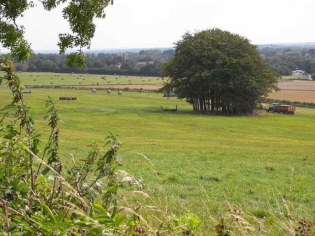
Undulating countyside between Lenham & Charing
The grassy track continued for about half a mile, before becoming a hawthorn-hedged tunnel, and then a more open track alongside harvested cornfields. Our first really open piece of walking occurred around Cobham Farm where we walked across the arable fields and passed some old barns. The A20 was reasonably close here, so there was some traffic noise, but it was good to be away from the motorways for a change. Soon the village of Charing came into sight, again with a square church tower, but once again this settlement was off route.

Looking back to Cobham Farm
View towards Charing church
On another ‘tarmac’ section, Dave had to cope with a difficult work call on his mobile – an irate customer wanted him to ship some air-conditioning part over from France ‘today’, even though it was a Sunday afternoon. “I can’t do anything until Monday morning!” was not surprisingly, Dave’s repeated cry. A pleasant wooded section followed, and here we felt a couple of spots of rain – but fortunately this was the worst weather we experienced all day.

Dave walking AND talking (men can multitask afterall!)

Westwell Downs woods
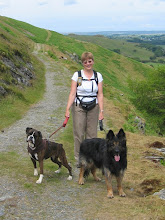
Anne’s idea to bring a more bowl-shaped container for ‘doggie drinks’, meant that Maggie was actually keeping hydrated this week, although still very much on her terms. Zuka also appeared to be drinking more than usual, which may have contributed to her developing ‘lovely’ hanging drools, which when dangled in the dirt, took on an even more menacing appearance. Suddenly no-one wanted her near their legs. Old Becky was coping very well with the walk, as I had hoped she would. She was up with the leaders most of the time, which did mean she kept doubling back regularly to see where I’d got to, but the extra mileage didn’t seem to bother her.

Ugh! - Doggy drool
Arriving at the hamlet of Dunn Street, we met a friendly chap who was trimming the hedge by a stile (how thoughtful). It turned out he was the owner of the camp site there, and we passed a few minutes in conversation with him.

Sally takes a photo
Our route then entered Eastwell Park estate, where we followed a gravelled driveway across arable fields, before dog-legging right and left through trees round the back entrance to the Eastwell Park Hotel grounds – “Private Grounds, Keep Out!” We crossed a field containing nearly ripe maize that towered over us, but fortunately the pathway through the plants was wide enough for it not to feel claustrophobic. In two other accounts of walking the NDW, I had previously read about a very large mansion built somewhere in the estate grounds, and thought it odd that I didn’t remember seeing it. Writing this now, I think the height of the maize crop must have hidden the building from our view, so maybe I’m not going blind after all – apart from missing the Marley Works earlier in the walk!

Path through maize field
Emerging onto a tarmac drive we diverted off route briefly – squeezing through a narrow kissing gate - to look at the remains of St Mary’s Church which is “being repaired by The Friends of Friendless Churches” would you believe? There is some disagreement as to whether the damage was caused by neglect or by bomb damage during World War II. The church stands on the banks of Eastwell Lake, apparently the second largest artificial lake in Kent. Maggie and Zuka took the opportunity to cool off in the smelly shallows (which led to ‘bog-dog’ odours in the car travelling back to Hollingbourne later).

Remains of St Mary's church

The dogs in Eastwell Lake
A family group of cyclists also viewing the church then told us about a brick tomb round the other side which is allegedly the final resting place of Richard Plantagenet, a bastard son of Richard III. We hurried round the church to take a look and a photo, while the dogs tried unsuccessfully to cadge food from a group of elderly picnickers, who had set up their chairs in the grounds of the church. I don’t think they were very amused – the pensioners, I mean, not the dogs.

A bit of history at St Mary's church

Eastwell Park
We returned to the Park driveway and followed it up a gentle incline to meet a fingerpost shared with the E2 European Path. This ultra long distance route starts in Galway, Ireland and continues for 3030 miles to Nice, France. It is probably impractical for us to attempt this one in day walks, don’t you think?

Dave considers continuing all the way to Nice on the E2 path

Path above Eastwell Manor
The final ½ mile took us past the main entrance to the Eastwell Manor Hotel (where there was obviously a wedding taking place, judging by the fancy chauffer driven cars on the drive), and across the A251 Faversham Road before reaching Boughton Lees village green. The green here is quite sizeable and there was a game of cricket in progress. Skirting round the field and past the club house, we arrived back at our cars parked outside the Flying Horse Inn.

Boughton Lees village green
Although the pub had a very nice garden, they had sadly finished serving food for the day, and as we all (except Dave) planned to eat before returning home, we decided to go back to Hollingbourne and eat at the Dirty Habit. This proved to be a more pleasant experience than most of us had expected (!), with Anne particularly enthusiastic about her Chicken Fajitas.

The Dirty Habit, Hollingbourne
Today’s section was certainly rather different to our previous walks. At just over 13 miles it was one of the shortest, ran more or less in a south-easterly direction for the entire distance, and was pretty flat. As so much of the path followed gravel tracks or tarmac lanes, it was a bit hard on the feet (Dave was particularly affected, I believe), but I do not recall a single time when I became short of breath, or really noticed the gentle ups and downs.


0 comments:
Post a Comment